先给大家展示实现后效果:
为直观期间,先贴出来我做的效果
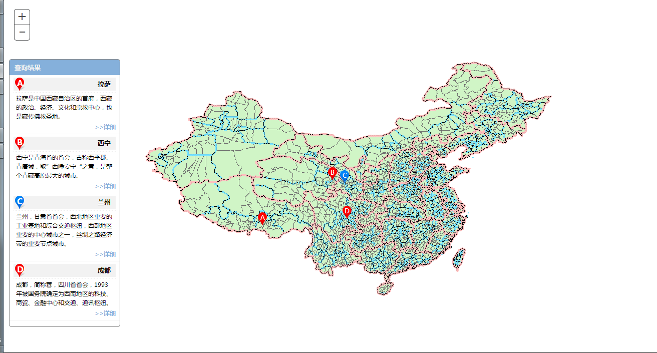
列表展示和地图展示以及联动
显示信息
实现思路:
1、列表与地图的互动
鼠标经过列表时,修改列表图标,并根据列表返回的值在地图上绘蓝色的marker;鼠标移出,修改列表图标为红色,清空地图marker图层。
关键代码:
title.on("mouseover",function(){ var attr = $(this).data("attr"); $("#icon"+attr.id).css("background","url('images/blue.png')"); var pt=new Point(attr.x,attr.y,{"wkid":4326}); var pms = new esri.symbol.PictureMarkerSymbol("images/blue.png",24,26) var gImg = new Graphic(pt,pms); gLyrHover.add(gImg); }); title.on("mouseout",function(){ var attr = $(this).data("attr"); $("#icon"+attr.id).css("background","url('images/red.png')"); gLyrHover.clear(); });2、地图与列表的互动
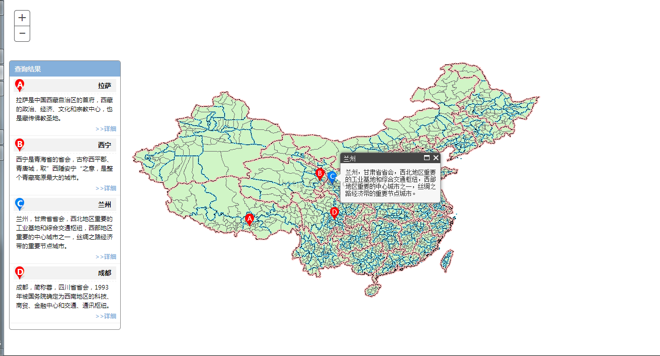
鼠标经过地图红色的marker时,修改对应列表图标,并将红色 marker的图片换成蓝色的;鼠标移出,修改对应列表图标,并修改marker为红色。
关键代码:
gLyr.on("mouse-over",function(e){ map.setMapCursor("pointer"); var sms = e.graphic.symbol; sms.url = "images/blue.png"; gLyr.redraw(); $("#icon"+e.graphic.attributes.id).css("background","url('images/blue.png')"); }); gLyr.on("mouse-out",function(e){ map.setMapCursor("default"); var sms = e.graphic.symbol; sms.url = "images/red.png"; gLyr.redraw(); $("#icon"+e.graphic.attributes.id).css("background","url('images/red.png')"); }); 3、地图上ABCD的文字是一个单独的图层,不参与互动。
4、数据以JSON形式存在。
var data = [ { "id":"A","name":"拉萨", "x":91.162998, "y":29.71042, "desc":"拉萨是中国西藏自治区的首府,西藏的政治、经济、文化和宗教中心,也是藏传佛教圣地。" }, { "id":"B", "name":"西宁","x":101.797303,"y":36.593642, "desc":"西宁是青海省的省会,古称西平郡、青唐城,取”西陲安宁“之意,是整个青藏高原最大的城市。" }, { "id":"C","name":"兰州","x":103.584297,"y":36.119086, "desc":"兰州,甘肃省省会,西北地区重要的工业基地和综合交通枢纽,西部地区重要的中心城市之一,丝绸之路经济带的重要节点城市。" }, { "id":"D","name":"成都","x":104.035508,"y":30.714179, "desc":"成都,简称蓉,四川省省会,1993年被国务院确定为西南地区的科技、商贸、金融中心和交通、通讯枢纽。" } ];完整代码:
<!DOCTYPE html> <html> <head> <meta http-equiv="Content-Type" content="text/html; charset=utf-8"> <meta name="viewport" content="initial-scale=1, maximum-scale=1,user-scalable=no"/> <title></title> <link rel="stylesheet" href="http://localhost/arcgis_js_api/library/3.9/3.9/js/esri/css/esri.css"> <style type="text/css"> html, body, #map { height: 100%; margin: 0; padding: 0; font-size: 62.5%; font-family:"微软雅黑"; } .search-box{ z-index: 99; background: #fff; border: 1px solid #888888; border-radius: 5px; width: 220px; max-height:600px; overflow-y: auto; position: absolute; top: 120px; left: 10px; } .search-box-title{ padding: 6px 10px; text-align: left; font-size: 13px; font-weight: bold; color: #f2f2f2; background: #85b0db; } .search-box-result{ list-style: none; margin-left:-40px; margin-top: 0px; } .search-box-result-item{ border-bottom: 1px solid #eeeeee; padding: 5px 8px; } .search-name{ float: right; font-weight: bold; font-size: 13px; margin-top: 3px; margin-right: 10px; } .search-name-title{ background: #f2f2f2; } .search-name-title:hover{ cursor: pointer; } .search-detail{ border-top: 1px dashed #eeeeee; margin-top: 3px; padding: 3px 5px; line-height: 18px; } .search-icon{ background: url("images/red.png"); width: 24px; height: 26px; background-repeat: no-repeat; } .search-text{ color: #ffffff; font-weight: bold; font-size: 16px; margin-left:7px ; } .detail{ color: #85b0db; font-weight: bold; text-align: right; } .detail:hover{ cursor: pointer; } </style> <script src="http://localhost/arcgis_js_api/library/3.9/3.9/init.js"></script> <script src="jquery-1.8.3.js"></script> <script type="text/javascript"> var map; var data = [ { "id":"A","name":"拉萨", "x":91.162998, "y":29.71042, "desc":"拉萨是中国西藏自治区的首府,西藏的政治、经济、文化和宗教中心,也是藏传佛教圣地。" }, { "id":"B", "name":"西宁","x":101.797303,"y":36.593642, "desc":"西宁是青海省的省会,古称西平郡、青唐城,取”西陲安宁“之意,是整个青藏高原最大的城市。" }, { "id":"C","name":"兰州","x":103.584297,"y":36.119086, "desc":"兰州,甘肃省省会,西北地区重要的工业基地和综合交通枢纽,西部地区重要的中心城市之一,丝绸之路经济带的重要节点城市。" }, { "id":"D","name":"成都","x":104.035508,"y":30.714179, "desc":"成都,简称蓉,四川省省会,1993年被国务院确定为西南地区的科技、商贸、金融中心和交通、通讯枢纽。" } ]; require([ "esri/map", "esri/layers/ArcGISTiledMapServiceLayer", "esri/geometry/Point", "esri/layers/GraphicsLayer", "esri/graphic", "dojo/_base/Color", "dojo/domReady!"], function(Map, Tiled, Point, GraphicsLayer, Graphic, Color) { map = new Map("map",{logo:false}); var tiled = new Tiled("http://localhost:6080/arcgis/rest/services/china/MapServer",{"id":"tiled"}); map.addLayer(tiled); var mapCenter = new Point(103.847, 36.0473, {"wkid":4326}); map.centerAndZoom(mapCenter,0); var gLyr = new GraphicsLayer({"id":"gLyr"}); map.addLayer(gLyr); var gLyrHover = new GraphicsLayer({"id":"gLyrHover"}); map.addLayer(gLyrHover); var gLyrLbl = new GraphicsLayer({"id":"gLyrLbl"}); map.addLayer(gLyrLbl); map.on("load",function(){ $("#search").show(); for(var i=0;i<data.length;i++){ var li = $("<li />").addClass("search-box-result-item").appendTo($("#result")); var name = $("<div />").addClass("search-name").html(data[i].name); var icon = $("<div />").addClass("search-icon") .attr("id","icon"+data[i].id) .append("<div class='search-text'>"+data[i].id+"</div>"); var title = $("<div />").addClass("search-name-title") .append(name).append(icon).appendTo(li) .data("attr",data[i]); var desc = $("<div />").addClass("search-detail").html(data[i].desc).appendTo(li); var more = $("<div />").addClass("detail").appendTo(li).html(">>详细"); title.on("mouseover",function(){ var attr = $(this).data("attr"); $("#icon"+attr.id).css("background","url('images/blue.png')"); var pt=new Point(attr.x,attr.y,{"wkid":4326}); var pms = new esri.symbol.PictureMarkerSymbol("images/blue.png",24,26) var gImg = new Graphic(pt,pms); gLyrHover.add(gImg); }); title.on("mouseout",function(){ var attr = $(this).data("attr"); $("#icon"+attr.id).css("background","url('images/red.png')"); gLyrHover.clear(); }); title.on("click",function(){ var attr = $(this).data("attr"); showCity(attr); }); var pt=new Point(data[i].x,data[i].y,{"wkid":4326}); var pms = new esri.symbol.PictureMarkerSymbol("images/red.png",24,26) var gImg = new Graphic(pt,pms,data[i]); gLyr.add(gImg); var font = new esri.symbol.Font(); font.setSize("10pt"); font.setFamily("微软雅黑"); var text = new esri.symbol.TextSymbol(data[i].id); text.setOffset(0,-2); text.setFont(font); text.setColor(new dojo.Color([255,255,255,100])); var gLbl = new esri.Graphic(pt,text,data[i]); gLyrLbl.add(gLbl); } gLyr.on("mouse-over",function(e){ map.setMapCursor("pointer"); var sms = e.graphic.symbol; sms.url = "images/blue.png"; gLyr.redraw(); $("#icon"+e.graphic.attributes.id).css("background","url('images/blue.png')"); }); gLyr.on("mouse-out",function(e){ map.setMapCursor("default"); var sms = e.graphic.symbol; sms.url = "images/red.png"; gLyr.redraw(); $("#icon"+e.graphic.attributes.id).css("background","url('images/red.png')"); }); gLyr.on("click",function(e){ var attr = e.graphic.attributes; showCity(attr); }); }); function showCity(attr){ var pt=new Point(attr.x,attr.y,{"wkid":4326}); map.infoWindow.setTitle(attr.name); map.infoWindow.setContent(attr.desc); map.infoWindow.resize(200,80); map.infoWindow.show(pt); map.centerAndZoom(pt,0); } }); </script> </head> <body> <div id="search" class="search-box" style="display: none;"> <div class="search-box-title">查询结果</div> <ul class="search-box-result" id="result"> </ul> </div> <div id="map"> </div> </body> </html> 以上内容就是代码家园小编给大家分享的基于Arcgis for javascript实现百度地图ABCD marker的效果,希望大家喜欢。
零七网部分新闻及文章转载自互联网,供读者交流和学习,若有涉及作者版权等问题请及时与我们联系,以便更正、删除或按规定办理。感谢所有提供资讯的网站,欢迎各类媒体与零七网进行文章共享合作。